Hi all
First draft
http://world.waze.com/wiki/index.php/New_Zealand/CityLabelNZ
As always I suspect robust decision on the pros and cons
Hi all
First draft
http://world.waze.com/wiki/index.php/New_Zealand/CityLabelNZ
As always I suspect robust decision on the pros and cons
Why did we need 4 of these?
In terms of page, I like the idea but im not sure how clear it is or that it covers enough detail.
How about something like this instead:
We probably should work out what we do about province (Waikato, Far North…) as well, I dont think its really needed and just clutters up the map.
ok
I’ve made some small changes to your above post and its still not quite right
back after work
sorry, the waze server crashed and I hit send a few times
I didn’t know
sorry
Shouldn’t that be for navigational purposes, why would anyone use Waze to work out someone’s postal address?
Where has the decision been formed that Rural areas are less important navigationally than urban areas. I am concerned that you are limiting wazes navigational functionality. I have been based most of my life in rural areas, most of my driving is still to rural areas. Personally I still think that pcp192’s idea of putting the local area name in the city field is sensible and logical on the open rural roads.
Lets take Hunua as an example the postal address is RD 3, Papakura so am I going to put all the names in this area as Papakura? Oh even better how about Ararimu, half of it would be labled Papakura and the other half Drury. This makes no sense whatsoever.
I think more thought and discussion needs to be put into this decision and that other peoples views should be taken into account, not summarily dismissed as they don’t agree with the writer.
ive tweaked the formatting a little does that work any better.
Fair call, although how do you determine the navigational city name? People should know how to determine the postal address for a road and most people would give that city for the purpose of navigation.
Its not limiting the navigation of Waze, its making the client display urban areas correctly. The alt names are used for the navigating for a place. pcp’s idea of having a city name against every primary name means that the client has no idea where the city/town actually is and can sometimes put it in the middle of a rural area.
If however an alt name is entered with the correct city name, the client will search the alt name as well and give the correct directions.
I dont follow you here? What you seem to have suggested is that the primary road should be labelled one or the other but not both? Where is the road? If someone was to drive to it what would be the address you gave for them to drive to?
I think you need to reread that topic as im not sure why you have decided that we don’t agree with the writer, that was the whole reason I suggested using alt names. Nobody actually paid attention to the original suggestion of using alt names and flamed me for my thinking, when I pointed it out a second time, then it seemed like everyone was on the same page as it covered everyone’s thoughts for display as well as navigation - Im really not sure why pcp then decided to go back on that and hasn’t replied to suggest why.
As ispy has mentioned tho it is for comment, if you have a reason for why it shouldn’t be done or doesnt work do chime in.
BTW, as an example of a road with the city name against the primary field and the map showing the town in an incorrect location take a look at Patea on the livemap:

https://world.waze.com/livemap/?lon=174.46208&lat=-39.73257&zoom=7&layers=BTTTT
Patea is next to the river (around where the BP is), not half way up the page.
I have no problems with the urban but I still trying to get my head around rural
as an example
https://world.waze.com/editor/?zoom=1&lat=-35.66897&lon=174.23124&layers=BFTFFTTTTTTFTFFTFTTTTFT
My postal address is
Mr ispyisail
111 Gumtown Road
RD 1 Kamo 0185
Result
Street Name: Gumtown Road
Primary: None
Alt: Kamo
Even though my official suburb is “Gumtown”
With that little bit at the end that the fourm didnt include, I see the issue.
Most people I know who live out in the Rural areas dont actually give the city, but since im in New Plymouth the RD addresses closely reflect the closest town not the suburb (eg. RD 1, New Plymouth)
The idea of the alt name is for navigation, so if I was driving from New Plymouth to you what address would you give me so that I dont go to Turua, Hauraki? And what would we call the city part so that people know what it is and could find it easily? as obviously city from the postal address doesnt work as I thought it would.
111 Gumtown Road, Gumtown, WhangareiI would think Whangarei would be the city part for the alt, or do people need to search on the Gumtown as well?
I also have another problem
https://world.waze.com/editor/?zoom=2&lat=-35.73201&lon=174.31441&layers=BFTTFTTTTTTFTFFTFTTTTFT
The suburb “woodhill”
I think there is a suburb in auckland also called woodhill, so I had to name it “woodhill (whangarei)”
I’m temped to try and name all streets and roads primary “Whangarei” and all alts their suburb names?
thoughts?
in google maps i can search with only
274 Gumtown Road, Whangareibut if you were using old fashion maps it wouldn’t be so much fun
I thought the idea of having the primary as the suburb was so the client showed the suburb. If you name them all Whangarei then they all just show as Whangarei. And you wouldnt be able to label it Woodhill as an Alt as it would still conflict with the other Woodhill.
The woodhill is a tricky one, I think the UK ( http://world.waze.com/wiki/index.php/How_to_label_cities_(United_Kingdom) ) manual does that trick.
I cant find anything about what the US does, although looking at there map they do the same thing as we are doing (City on primary and above, suburb on standard) (eg. St Louis: http://www.waze.com/livemap/?zoom=10&lat=38.61183&lon=-90.23725&layers=BTTTT )
Well we have established that Google doesnt acknowledge Gumtown, you can search for Gumtown Road, Kamo tho. We could have an alt entries for all three: Gumtown, Kamo, and Whangarei but it would get really niggly to maintain. I also dont think the client works with part of name (eg. Gumtown/Kamo, Whangarei).
How about we choose Northland the area, map and name the whole area using the proposed method and then see what occurs on the live map and Waze client. I think Northland would be a reasonable choice as Whangarei is a large enough city to have a few suburbs but is not so unwieldly as say Auckland. There is the advantage that ispyisail lives in Whangarei and I originally came from the Dargaville/ Pouto Area. We could probably apply the rules over this area without too much trouble in say a 3 week period if a few of us work on it.
Hi all, as noted by someone in a previous post I’ve been absent from the discussion for a few days. Sorry about that - I’ve had a busy time at work for the past couple of weeks and not much time to devote to either editing or keeping up on the discussions. Having said that I was reading some of it just didn’t have time to respond. I did give it thought though 
Here’s a few of my thoughts:
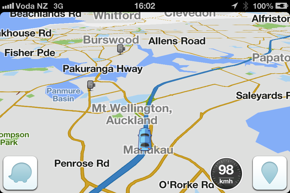 it currently shows suburb names (admitedly not all correct yet). My question is - if we name all primary streets using ‘Auckland’ what will you see on the client in this scenario? As all ‘Streets’ are not visible won’t it show just Auckland? That is an undesirable outcome.
The biggest problem here is that we are trying to create a cludge to solve the fact the Waze cannot achieve exactly what we want. If it had more fields for naming and the ability to geographically pinpoint the centre of any town, then we wouldn’t need to even consider a complex set of rules where the city field is used differently in various scenarios and unfortunately the rule as currently proposed does not suit all scenarios.
As has been pointed out by others in previous posts, Waze is designed for a purpose - to route intelligently between two known points. At this time it does that pretty well - getting better with more users of course. Over time I’m sure more functionality will be added that makes it even better but for now, there is no silver bullet to make it work in all the ways (excuse the pun ) we want it to. Perhaps we have to accept that the app is limited and stick to the principal of keeping it as simple as possible.
I once though/agreed with this concept but no longer
Who navigates to “Auckland” in fact who navigates to a suburb, im going to suggest not many people. You navigate to street level and use suburb/city to make sure its the right one.
No, have a look at Whangarei, it has been named with our new/proposed naming system for a few update cycles now .
strongly agree
But I disagree that just because waze has some design issues we should just give up
Does that mean that St Louis and its suburbs actually show what you’ve been suggesting all along that by using the area name (ie suburb name in a city or the local area in rural areas) used on all roads in that way will display the areas correctly?
I think so yes, but there will always be exceptions given the limitations of the apps architecture.
I thought that was one of the things ispy and nzhook had wanted to achieve based on the comment about towns like Patea. Though, having another look at Patea, if you search for Patea on the live map or on the client, it takes you to the centre of the town. I don’t know why it shows the label on the map where it is but does it really matter? If a road is in Patea then why not label it so?
I agree with what ispy said above and we don’t need to build the map in a way that makes this work - that level of funcationality may come in the future. Right now, we should just name the roads correctly without leaving fields blank and the map will display as well as it can. As you say, it’s more important that people can serach for the destination road and use the suburb/city to confirm they have selected the correct one. If we have roads in rural areas with no city field, how will they do that, especially if it’s a long road that crosses boundaries between towns or rural areas? Ararimu Rd is a good example as it flows from Ramarama, to Ararimu, to Hunua.
True - but at the same time Whangarei disappears as you zoom out so what’s been achieved by naming all the primary streets as Whangarei? All that’s visible when zooming out is the surrounding suburbs. How would the map differ if in the suburban areas ALL streets had the suburb name?